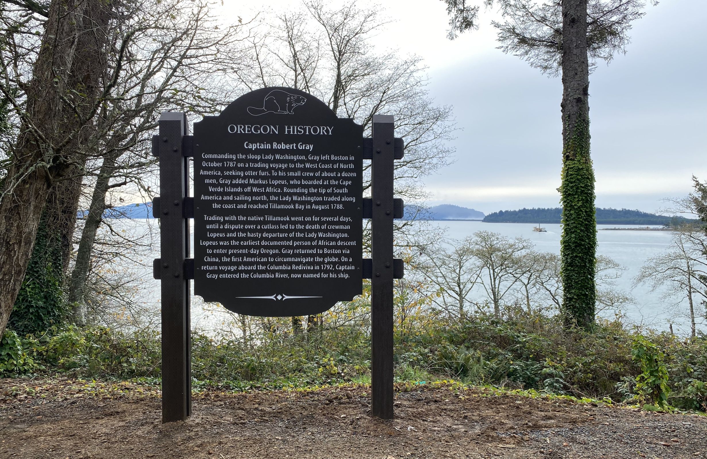
OTE - Oregon Travel Experience

Historic La Grande

Posted on: September 25th, 2011 in Historical Marker Audio Tours, Historical Marker Details |

La Grande was the first town permanently settled in Northeastern Oregon. Daniel Chaplin laid out the original ‘Old Town’ in spring of 1862 and Ben Brown built the first house, a log cabin, alongside the Oregon Trail at the corner of B Avenue and Cedar Street.
As the prime lands of western Oregon were settled, and then gold was discovered in eastern Oregon, a reverse migration used the Oregon Trail from …

Read More

Japanese Attack on Oregon

Posted on: September 25th, 2011 in Historical Marker Audio Tours, Historical Marker Details |

Prior to the attack on Pearl Harbor, a contingent of Japanese I-Class submarines sailed from Yokosuka via the Marshall Islands to take up positions off Hawaii and the coast of North America. Five of these vessels carried midget two-man submarines and 11 carried aircraft.
Early on the morning of September 9, 1942, the Japanese submarine I-25 surfaced off Brookings. The crew quickly assembled a specially designed seaplane, and within a few minutes …

Read More

Deschutes River Crossing

Posted on: September 23rd, 2011 in Historical Marker Details |

Subject: Point where the Oregon Trail crossed the Hazardous Deschutes River.
The Oregon Trail crossed the hazardous Deschutes River at this point by floating the prairie schooners and swimming the livestock. An island at the river mouth was often utilized when the water was high and the ford dangerous. Pioneer women and children were frequently ferried across the stream by Native canoe men who made the passage in exchange for bright colored …

Read More

Indian Trails

Posted on: September 19th, 2011 in Historical Marker Details |

An ancient trail passed through here as part of an extensive Indian trade network linking peoples of the Northern Great Basin and Columbia Plateau to those living west of the Cascades. Obsidian, bear grass, and slaves were transported over these trails to major trading locations along the Columbia River in exchange for dried salmon, smelt, sturgeon and decorative sea shells. The long established route was later used by Peter Skene …

Read More

Homeland of the Cow Creeks

Posted on: September 19th, 2011 in Historical Marker Details |

Subject:History of the Cow Creek Band of Umpqua Indians
This portion of the southwest Oregon is homeland to the Cow Creek Band of Umpqua Indians. They thrived here for thousands of years before contact with Euro-Americans. Living in plank-house villages, they followed a seasonal round of resource use. Moving from summer camas meadows and salmon fisheries along the rivers to the high country, they picked huckleberries and hunted for deer in …

Read More

Homeland of the Burns Paiute

Posted on: September 19th, 2011 in Historical Marker Details |

Homeland of the Burns Paiute marker

This region is the homeland of the ‘Wadatika’ (wada seed eaters), a nomadic band of Northern Paiute Indians. Today, the descendants of these people are known as the Burns Paiute.
Armed conflicts between ranchers and the ‘Wadatika’, during the late 1800s, led President Ulysses S. Grant to create the 1.8 million-acre Malheur Reservation in 1872. Pressure from settlers opened portions of the reservation to grazing and …

Read More

Heppner Flood

Posted on: September 19th, 2011 in Historical Marker Details |

OREGON HISTORY – SUNDAY, JUNE 14, 1903
A flash flood swept down on Heppner, and caught residents unaware, killing hundreds and destroying nearly the entire town. A cloudburst hit in Balm Fork Canyon, south of Heppner. The rushing waters tore down the narrow canyon, picking up haystacks, chicken pens and livestock and piled it all up behind a steam laundry that straddled the canyon near the edge of town. This very …

Read More

The Cascadia Earthquake and Tsunami of 1700

Posted on: September 19th, 2011 in Historical Marker Audio Tours, Historical Marker Details |

 
During the 18th century, Native American villages occupied the mouths of nearly every stream along this coastline – including here at Siletz Bay.
References to great flooding and ground shaking events are recorded in the oral traditions of many Pacific Northwest coastal tribes. These stories include instructions about how to prepare for large flooding events.
On January 26, 1700, the earth shook violently in the throes of a magnitude 9+ earthquake that …

Read More

Great Basin

Posted on: September 19th, 2011 in Historical Marker Details |

This site marks the northern limit of the Great Basin, a region some six hundred miles long and up to five hundred miles wide. It began forming 17 million years ago as the result of regional uplift and east west stretching by geologic forces that continue today. This stretching created a pattern of north trending mountain ranges separated by broad flat valleys. Precipitation that falls within the Great Basin leaves …

Read More

Gray, Captain Robert

Posted on: September 19th, 2011 in Historical Marker Details |


Captain Robert Gray, commanding the sloop Lady Washington, left Boston in October 1787 on a trading voyage to the West Coast of North America, seeking otter furs. To his small crew of about a dozen men, Gray soon added Markus Lopeus, who boarded at the Cape Verde Islands off West Africa. Rounding the tip of South America and sailing north, the Lady Washington traded along the coast, and reached Tillamook …

Read More