Payments
The real story behind rest area panhandling
Posted on: October 2nd, 2013 in Rest Areas |
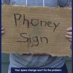
Why do we see “phony sign” posters in the travel information kiosks?
As a traveler who has stopped at many rest areas in your lifetime, you may have witnessed the following: individuals standing with scrawled messages on cardboard signs in front of public restrooms or near the parking lot. The signs can be quite heart-wrenching, stating anything from “Homeless with Children” to “Veteran, anything helps, God bless.”
At first glance, many of …